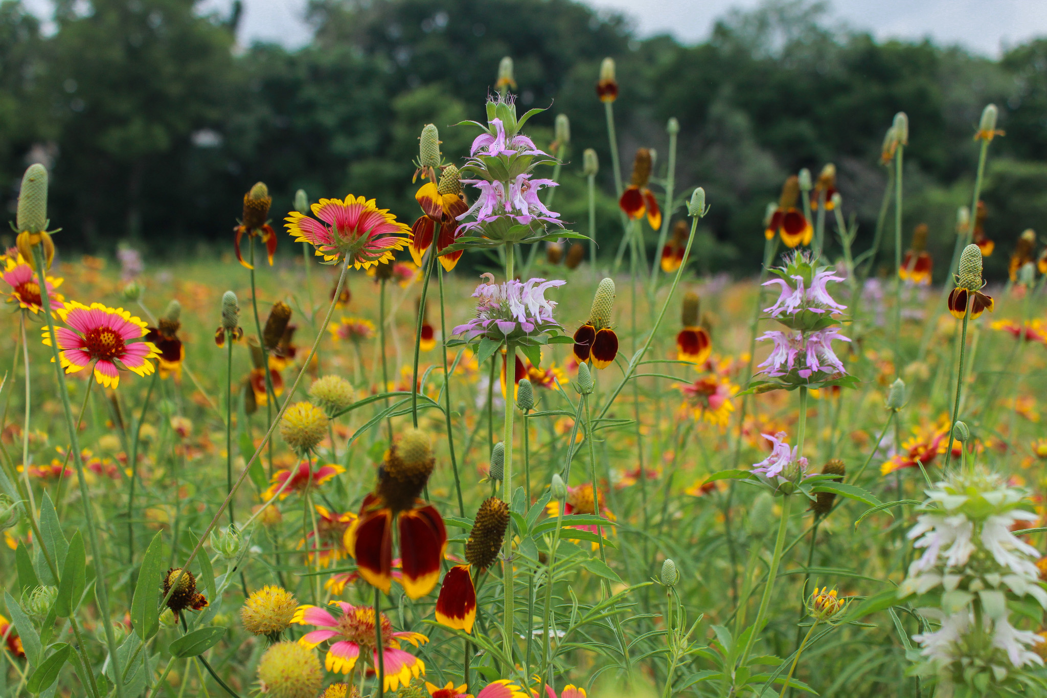
In the 1930s Texas State Climatologist Isaac Klein reportedly said, “Texas is a land of eternal drought, interrupted occasionally by biblical floods”, and right now the state is seeing a little of both. While parts of southeast Texas had severe flooding earlier last month and North Texas is experiencing one of its wettest springs on record, the Texas Hill Country remains in drought and was blasted by its first heat dome of 2024 in late May. Last month saw only seven days with below-normal high temperatures.
Additionally, the Austin/San Antonio office of the National Weather Service issued an Excessive Heat Warning earlier than ever before, surpassing the previous record set on June 11, 2022, according to KVUE Austin. Despite a rainy May, the District remains in Stage II Alarm Drought, requiring all District permittees to continue the implementation of mandatory pumpage reduction measures.
Rainfall
This May, the District received an average of 4.7 inches of rainfall, slightly below the historical monthly average of 5 inches (Figure 1). Despite being 0.3 inches below the month’s average, 2024 has provided a 2.9-inch surplus in rainfall compared to the annual historical average through May.
The District will require above average rainfall across the recharge zone to get out of the current drought that’s been ongoing for two consecutive years. June is typically the third rainiest month of the year in the District behind May and October.
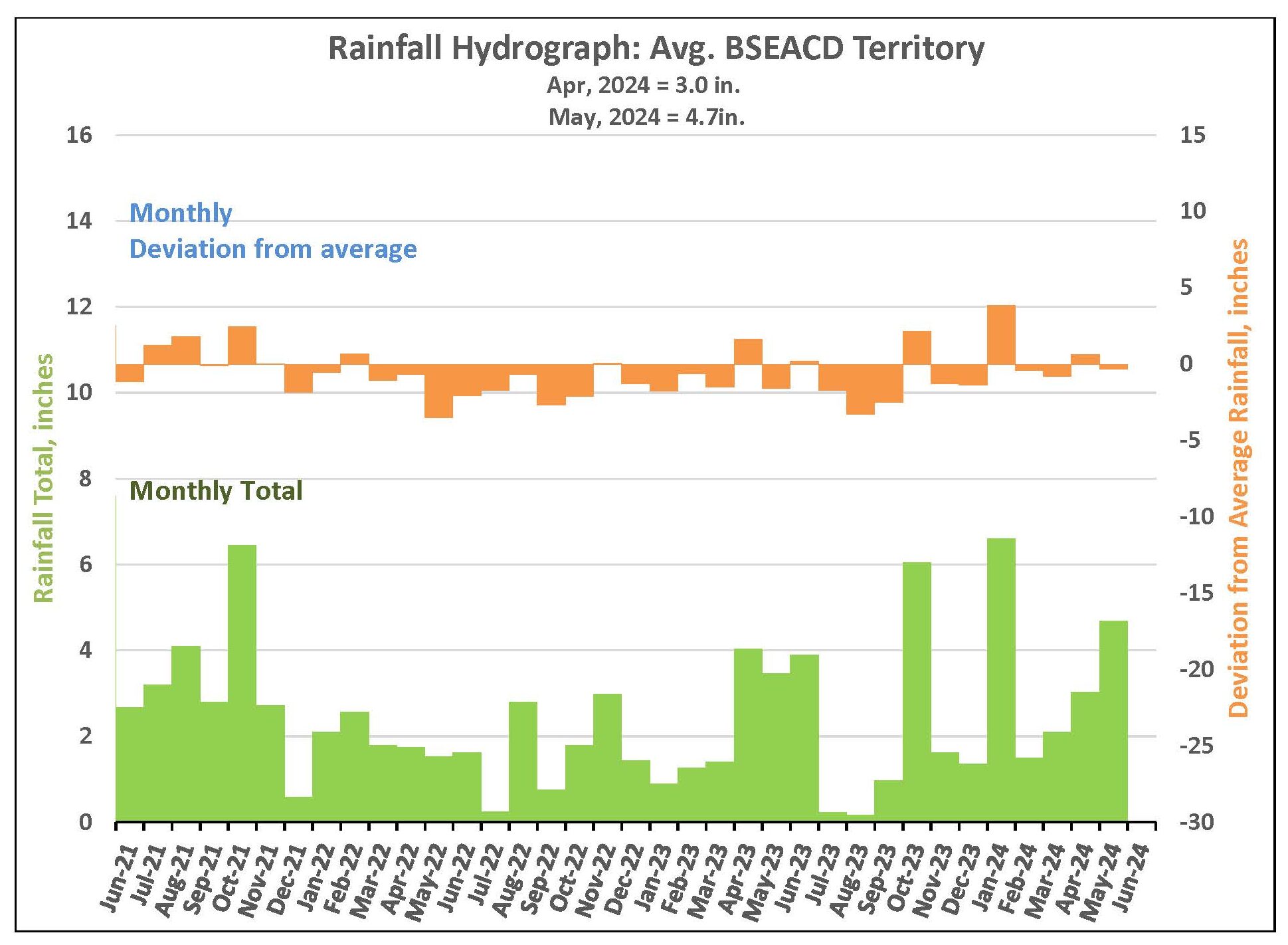
Figure 1. Monthly deviation from average and monthly total rainfall in District’s territory.
Barton Springs Flow
On June 4, the 10-day average flow at Barton Springs is 36 cubic feet per second (cfs), maintaining flows inside the Stage II Alarm Drought status (Figure 2). Late May rains provided a significant boost, raising the spring flow from 31 cfs on May 27 to 50 cfs by June 3, a much-needed improvement in declining spring flows.
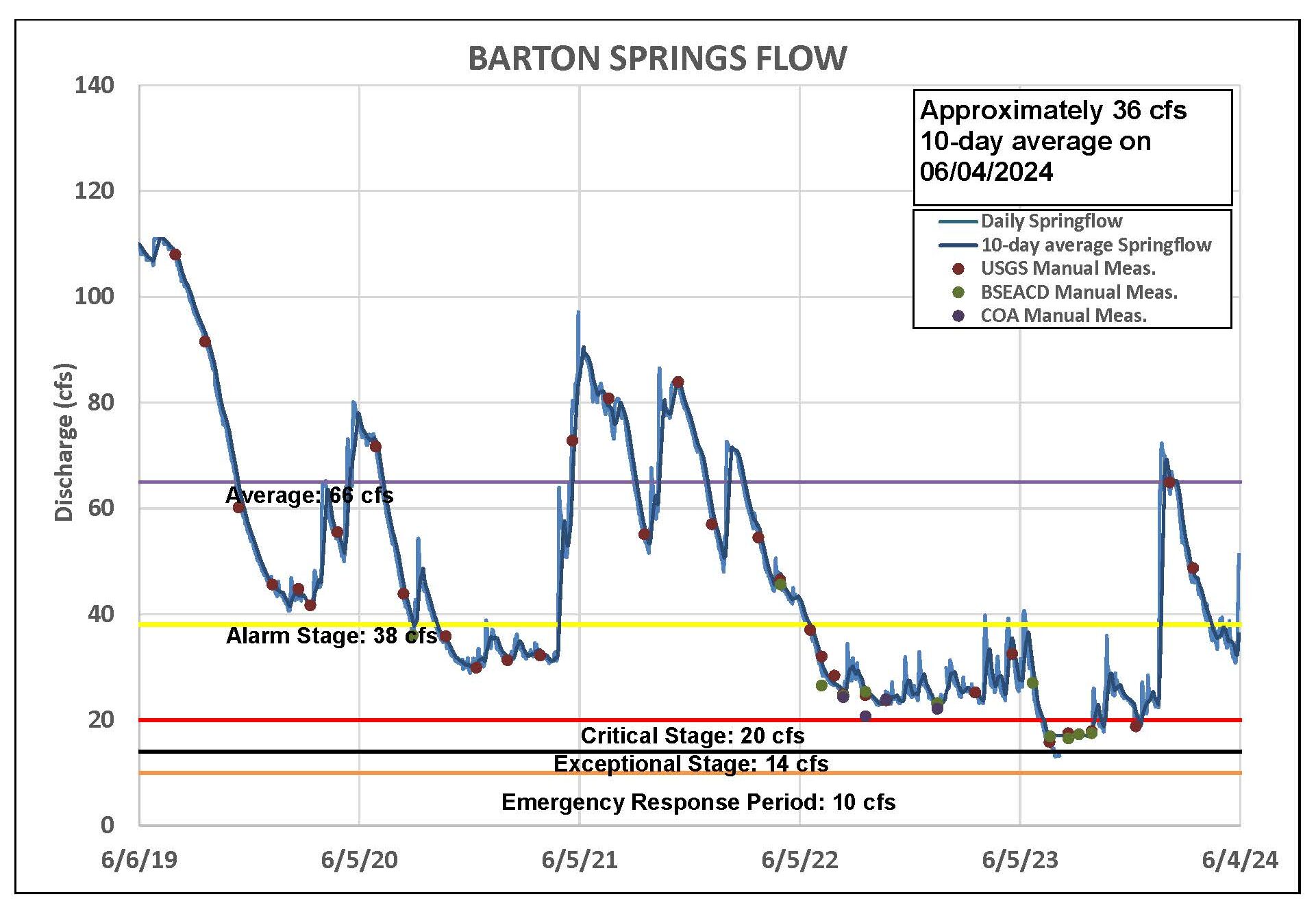
Figure 2. Barton Springs flow for the last five years.
Lovelady Monitor Well
As of June 4, the 10-day average water level at Lovelady stands at 467.4 feet above mean sea level (ft-msl), which is about 5 feet above the Stage III Critical Drought status (Figure 3). Despite nearly average rainfall in May, water levels continue to decline due to insufficient recharge. However, Lovelady levels typically respond slowly to rainfall, so a rise in aquifer levels might be observed in the next couple of weeks in response to late May rains.
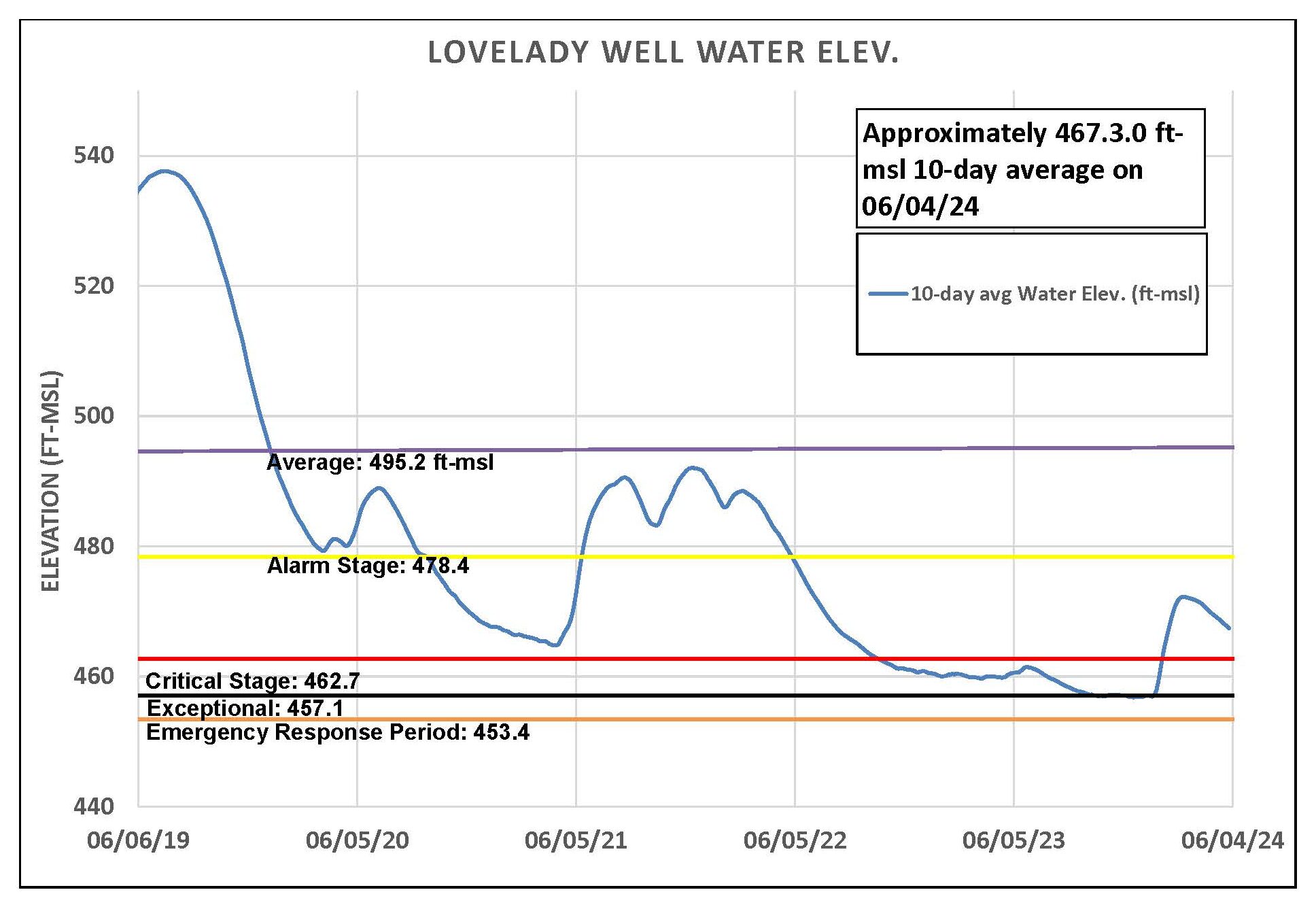
Figure 3. Lovelady groundwater level over the last five years.
Upper and Middle Trinity
Water levels in the Upper Trinty (green) have nearly returned to levels prior to the surge in January and have displayed minimal to no response to subsequent rainfall (Figure 4). Since late March, the Middle Trinity (purple) has maintained a more subdued holding pattern with only a subtle decline becoming evident in late April.
Jacob’s Well Spring showed an encouraging response to May rainfall, peaking at 16 cfs on May 31. Although the flow has since dropped to about 4 cfs, this is still an improvement from 0 cfs before May 29. Similarly, the Blanco River at Wimberley experienced two surges in late May, reaching a peak flow of 148 cfs on May 31. The current flow is now in the mid-20s.
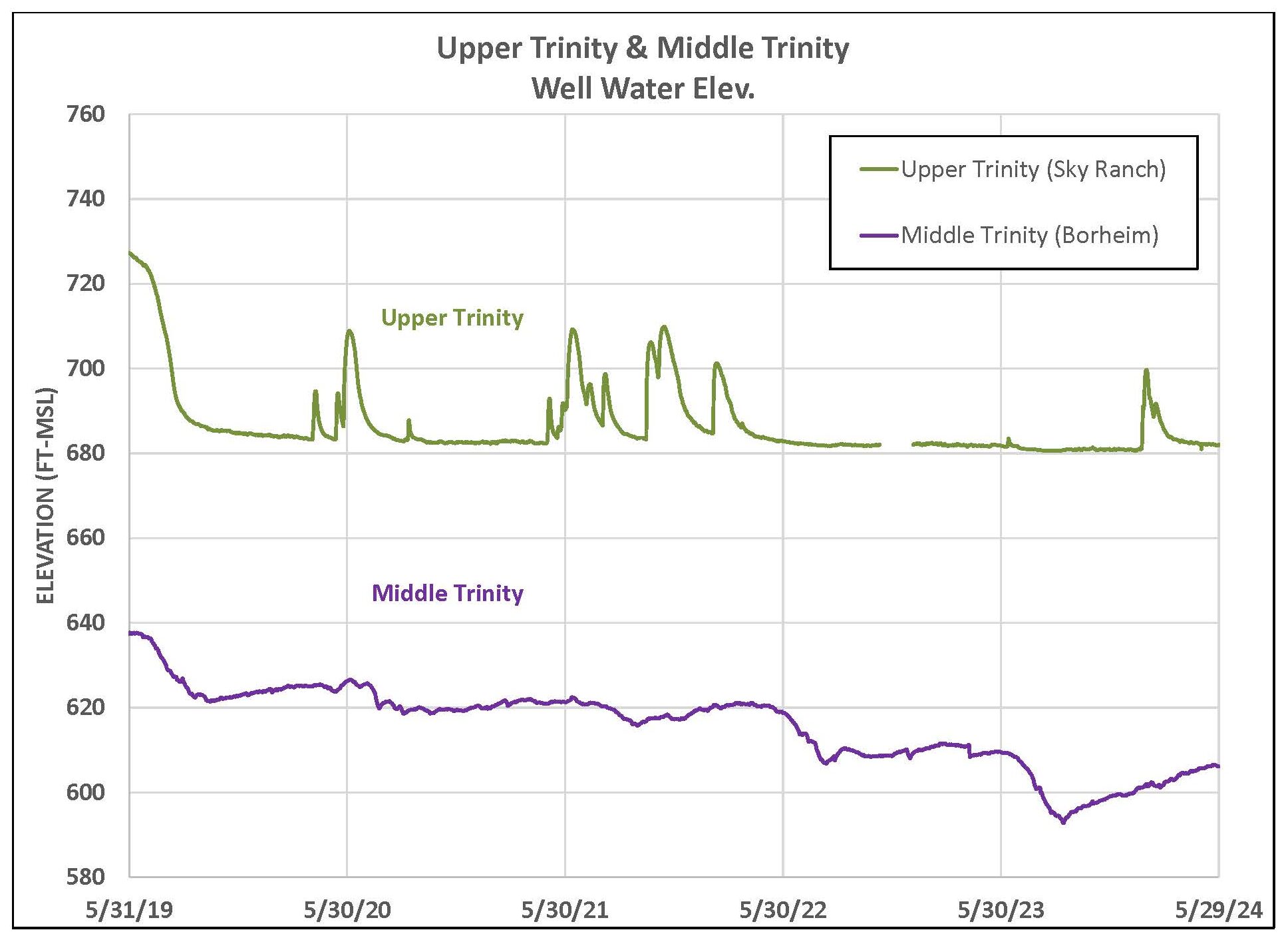
Figure 4. Water levels in an Upper Trinity well (green) and Middle Trinity well (purple) over the last five years.
Highland Lakes
May rains were good to Lake Buchanan where it increased from 42% full last month to 74% now. Lake Travis showed a less dramatic month-to-month increase going from 38% full to 42%. Combined, these lakes are sitting at 56% capacity.
Forecast
NOAA says “there is a one-in-three chance that 2024 will be warmer than 2023 and a 99% chance that 2024 will rank among the five warmest years on record”. It’s also predicted this year will have a more active than normal hurricane season in the Atlantic. Even so, Dr. John Neilsen Gammon, Texas State Climatologist, states that more hurricanes don’t necessarily mean more overall rain. They simply concentrate the rainfall to areas in its path. This means that while there’s a chance this active hurricane season could bring a drought busting rain, it’s not guaranteed.
Conservation – Rainwater Harvesting
With a hot and dry forecast for summer 2024, continuous conservation is key. A great way to help make rain go further is through rainwater harvesting systems, which catch, divert, and store rainwater for later use. The collected water can reduce reliance on surface and groundwater sources by being used for watering plants both indoors and outdoors, washing vehicles, and, if treated, drinking water. In addition to reducing demand on existing water supplies, rainwater harvesting helps reduce run-off, erosion, and contamination of surface and groundwater.
Below are resources providing basic information on rainwater harvesting:
- Texas A&M Agrilife Extension – Rainwater basics, resources, examples, and more
- CDC – Rainwater collection as drinking water
- City of Austin – Austin water conservation rebates and programs including rainwater harvesting
- City of San Marcos – Water rebate programs including rainwater harvesting
- Texas Water Development Board – Sales tax exemptions for water related equipment
