Introduction
A consortium of central Texas agencies and groundwater scientists conducted a series of studies of the Trinity Aquifers that culminated in publication of the Hydrogeologic Atlas of the Hill Country Trinity Aquifer (Wierman et al., 2010). A continuation of those studies has revealed a hydrologic connection between the Middle Trinity Aquifer and the Blanco River and portions of Upper Onion Creek (Hunt et al., 2016; 2017).
Some members of this earlier team have concentrated further studies on the portion of Onion Creek upstream of the Edwards Aquifer Recharge Zone. Initial hydrogeologic studies identified segments of upper Onion Creek that recharge surface water and have an influence on the water levels and chemistry of the groundwater in the Middle Trinity Aquifer in certain areas. Hydrogeologic and dye-trace studies are currently being conducted to determine the fate of surface water in Onion Creek recharging the Trinity Aquifers. One question is to determine if recharged surface waters re-emerge further downstream in springs or migrate deeper into the aquifer to discharge from wells, or both. To address these questions, scientific staff from the Hays Trinity Groundwater Conservation District (HTGCD), City of Austin (CoA), Barton Springs/Edwards Aquifer Conservation District (BSEACD), and the Meadows Center for the Environment (Texas State University, TSU) met in 2016 and 2017 to plan a dye-trace study of the upper Onion Creek watershed. Plans for the tracing were also done in consultation with Ozark Underground Laboratory.
This memo is meant to provide an update to the ongoing dye-trace studies in the upper Onion Creek watershed near Dripping Springs in Hays County.
Method
Dye tracing is a long-established, safe, and scientifically sound approach to characterize surface and groundwater interactions. Non-toxic fluorescent dyes are introduced into recharge features, such as caves, sinkholes, swallets, and fractures, or into streams that flow across the recharge zones of an aquifer. Water samples and absorbent charcoal packets are collected routinely at downgradient wells and springs and analyzed for the presence of the injected dyes (Aley, 2002).

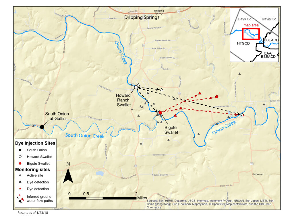
On December 4, 2017 dye was introduced into two karst features along Onion Creek in the vicinity of the City of Dripping Springs (Figure 1). The first feature was Bigote Swallet, a recharge (karst) feature where the stream disappears into the bedrock approximately 1.2 miles downstream from RR12. The second injection was into a recharge feature in the Howard Ranch subdivision approximately 800 feet downstream of the RR 12 Bridge. On Wednesday, December 7, dye was introduced into South Onion Creek, immediately downstream of the bridge at Gatlin Creek Road, where it was carried downstream to losing portions of the stream by natural creek flow. Different dyes were injected at each location (Table 1).
| Feature | Date |
| Bigote Swallet | 12/4/2017 15:00 |
| Howard Ranch Swallet | 12/4/2017 16:30 |
| South Onion Creek (at Gatlin Rd) | 12/7/2017 15:15 |
In the days and weeks following dye injection, water and charcoal packets were collected from a monitoring network of 35 wells and surface-water sites (Figure 2). Once collected, samples were shipped to Ozark Underground Laboratory (OUL), a lab in Missouri that specializes in analyses for dye-trace studies. OUL is equipped to analyze the samples for each of the three types of dye used in the study. A continuously recording fluorimeter was installed at Emerald Spring by BSEACD staff. In addition, some duplicate samples were qualitatively analyzed for screening purposes at the BSEACD using a desktop fluorimeter.
Initial Results
Sampling of wells and springs will continue for several months after the dyes were injected. Analyses of the water and charcoal packets from the first round of sampling (up to one week after injection) had positive detections of the dyes at several locations.
Figure 3 is a map showing the three injection sites and the monitoring sites. Sites with positive dye detections and the inferred groundwater flow routes are indicated. The presence of the dye injected into Bigote Swallet was detected in at least one Middle Trinity Aquifer well about 1.25 miles east of the injection point. Visible concentrations were noted by the well owner within one day, which were later confirmed by lab analysis (Figure 2).

The presence of the dye injected into Howard Ranch Swallet was detected at a nearby Middle Trinity Aquifer well about 300 feet north of the injection site within one day. In addition, the dye was detected in a spring within Onion Creek about 1 mile south.
These initial data support the findings of Hunt et al., 2016 demonstrating clear surface and groundwater interactions along Onion Creek. These results indicate that Onion Creek is hydrologically connected to shallow springs and also to deeper Middle Trinity Aquifer wells and have rapid groundwater flow velocities.
This memo presents the initial results from only one round of sampling. Additional samples will be collected over the next few months to further characterize the surface and groundwater interactions. A technical report will be completed by the investigating agencies to document and interpret this first phase of dye tracing.
Contributors
Hays Trinity Groundwater Conservation District
Jeff Watson, Hydrogeologist
Alex S. Broun, P.G.
Barton Springs Edwards Aquifer Conservation District
Brian A. Smith, PhD, P.G.
Brian B. Hunt, P.G.
Justin Camp
City of Austin Watershed Protection
David A. Johns, P.G.
Meadows Center for Water and the Environment at Texas State University
Douglas A. Wierman, P.G.
References
Aley, T., 2002, Groundwater Tracing Handbook, Ozark Underground Laboratory, Protem, Missouri, 35 p.
Hunt, B. B., B.A. Smith, M.O. Gary, A.S. Broun, D.A. Wierman, J. Watson, and D.A. Johns, and, 2017, Surface-water and Groundwater Interactions in the Blanco River and Onion Creek Watersheds: Implications for the Trinity and Edwards Aquifers of Central Texas. South Texas Geological Society Bulletin, v. 57, no. 5, January 2017, p. 33-53.
Hunt, B. B., A. S. Broun, D. A. Wierman, D. A. Johns, and B. A. Smith, 2016, Surface-water and groundwater interactions along Onion Creek, Central Texas: Gulf Coast Association of Geological Societies Transactions, v. 66, p. 261–282.
Wierman, D.A., A.S. Broun, and B.B. Hunt (Eds), 2010, Hydrogeologic Atlas of the Hill Country Trinity Aquifer, Blanco, Hays, and Travis Counties, Central Texas: Prepared by the Hays-Trinity , Barton/Springs Edwards Aquifer, and Blanco Pedernales Groundwater Conservation Districts, July 2010, 17 plates+DVD.
- Staff Presentation at 1/11/18 Board Meeting
- Interagency Technical Memo Update on Upper Onion Dye Trace (1/10/2018)