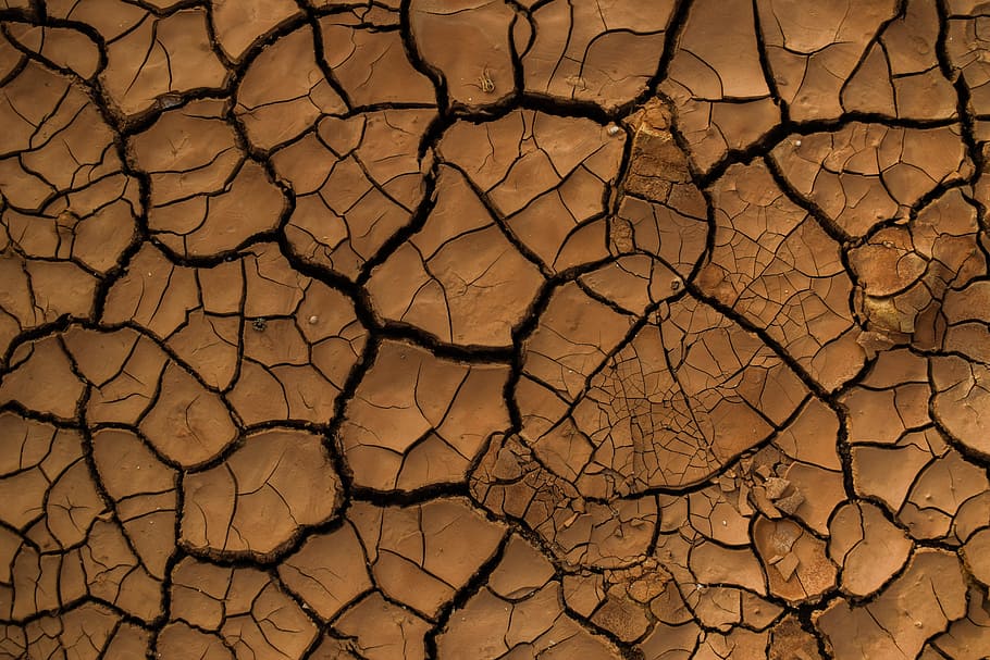
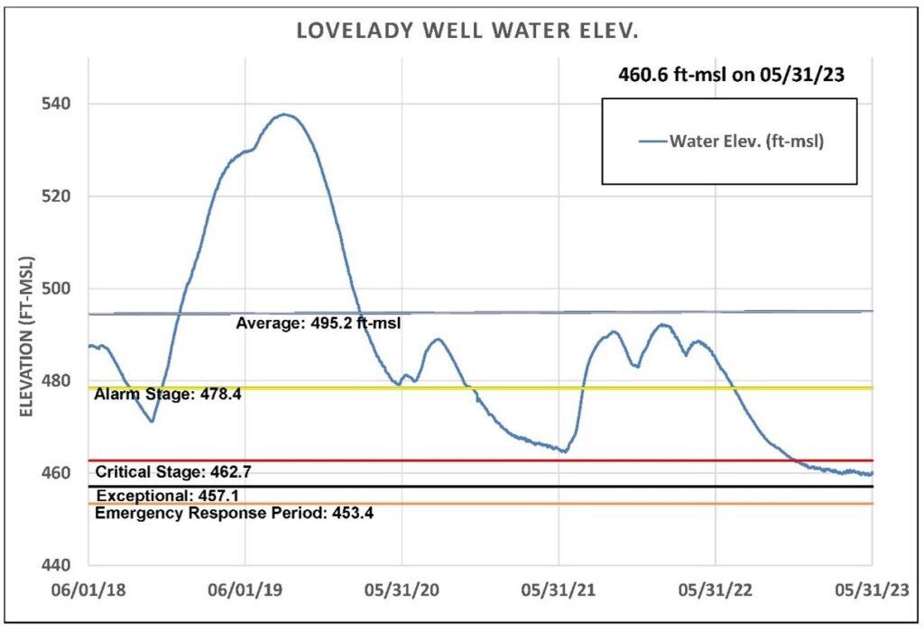
We’re over halfway through calendar spring and, while April and May rains have provided much-needed recharge to the Edwards and Trinity aquifers, we remain in Critical Drought status (Stage III). It was officially declared on October 20, 2022 when one of the District’s drought triggers, Lovelady monitor well, passed below its Critical Drought (Stage III) trigger on October 17, 2022.
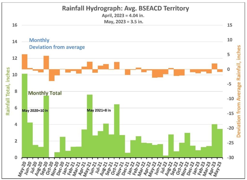
April rainfall delivered 4 to 5 inches across the Hill Country, about 2 inches above the monthly historical average (Figure 1). This makes April the first month with above average rainfall since November 2022. May rainfall came in just under its historical monthly average (4.4 inches) providing 3.6 inches. In January through May 2023, we received an average of 11 inches, just 2.4 inches short of this year’s historical average.
Lovelady initially crossed under the Stage II trigger on May 26, 2022 and under Stage III on October 17, 2022. On May 31, the Lovelady monitor well had a level of 460.6 ft-msl, 2.1 ft below the trigger level for Critical Drought (Stage III) and about 3.5 ft above Stage IV Exceptional Drought (Figure 2). While water levels continue to decline, the speed of decline has slowed with the help of the April and May rains.
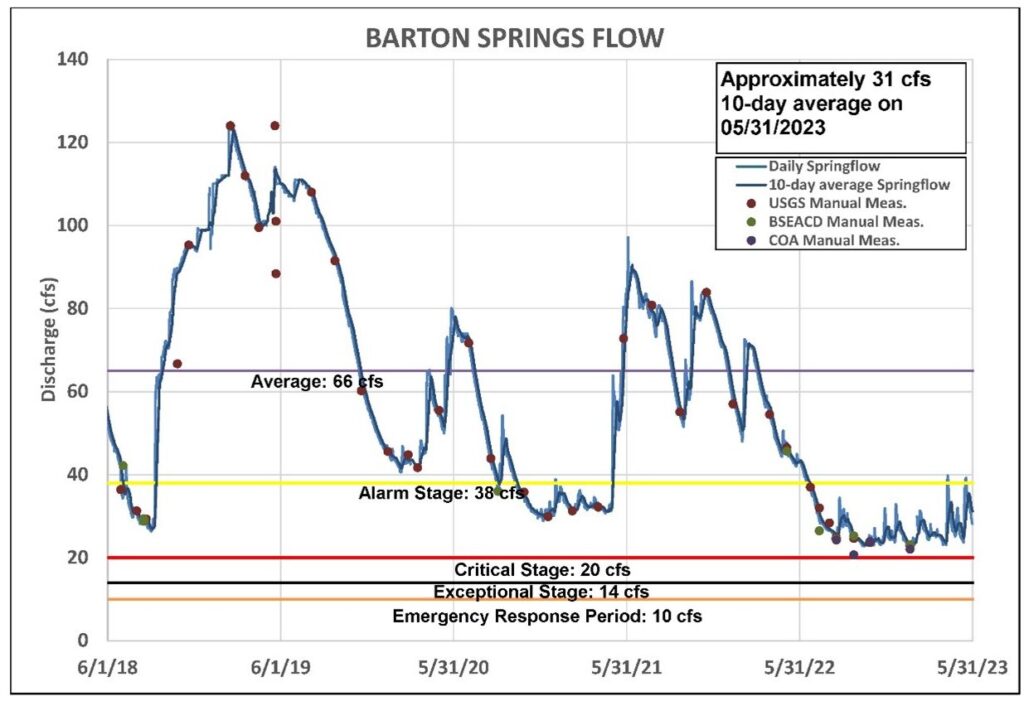
Barton Springs crossed under the Stage II drought trigger in late June 2022. On May 31, Barton Springs was flowing at 31 cfs (10-day average), 7 cfs below the Stage II Alarm drought trigger point of 38 cfs (Figure 3). The Stage III Critical trigger is 20 cfs, and it’s possible Barton Springs could cross this threshold in mid-to-late summer without additional rain.
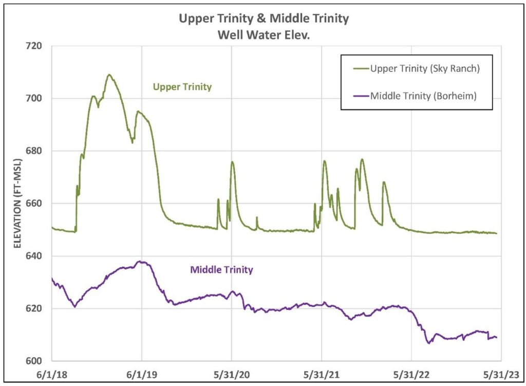
Trinity groundwater levels have essentially remained in a holding pattern, not significantly rising, or falling since early spring, as seen in Figure 4. Some minimal flow has also been restored at Jacob’s Well and the Blanco River.
We are still amid the wettest months of the year, typically March through June, and we’ve seen some improvement since last year. In 2022, April and May provided just 3.3 inches. This year we’ve received more than double that (7.5 inches). While Memorial Day weekends have had a history of producing big rains and notable floods across Central Texas, the drought buster we desperately need in 2023 has yet to materialize and groundwater levels and spring flows remain alarmingly low. We’re through the meteorological spring and this is distressing as we enter summer and the beginning of the low-rain/high-water-use period in Central Texas.
On a global climatic scale, the National Oceanic and Atmospheric Administration (NOAA) Climate Prediction Center is observing several weather phenomena and their potential impacts, including El Niño as well as the beginning of hurricane season.
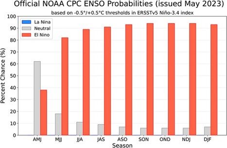
An El Niño Watch remains in place, with El Niño conditions likely to develop within the next couple of months and persist (greater than 90% chance) into the winter (Figure 5). This could mean more average or above average rainfall conditions in the months to come and bolster against the usual Texas summer dryness. This would be a critical step in staving off an unprecedented descent into Stage 4 Exceptional Drought, which has been an expected consequence of slowing spring flow and water level declines.
June 1 also marks the start of hurricane season, which runs through November, and NOAA predicts a “near-normal” year, making this the first time in 8 years that the May outlook hasn’t forecast an above-average number of storms. However, this is an unusual year. According to NOAA, depending on certain sets of factors, El Niño conditions have the potential to either increase or disrupt the development of hurricanes, making it difficult to predict if the hurricane season will enhance rainfall for Central Texas.
We’ve been in a long pattern of below-average rainfall and streamflow, which has elevated our need to focus on our community coming together to protect groundwater supplies, spring flow, and the overall health of our creeks and rivers. With some potential relief on the horizon, we should continue our conservation efforts to contribute to a stronger recovery from this long period of Central Texas drought.
Other useful links:
- Drought Media Toolkit
- Press Release Archive
- Drought Status Page
- Drought Management Page
- Drought Information/Resources
BSEACD is a groundwater conservation district charged by the Texas Legislature to preserve, conserve, and protect the aquifers and groundwater resources within its jurisdiction, which includes parts of three central Texas counties. It is governed by a Board of five elected directors and staffed with hydrogeologists, groundwater regulatory compliance specialists, environmental educators, geospatial systems specialists, and administrative support personnel.
