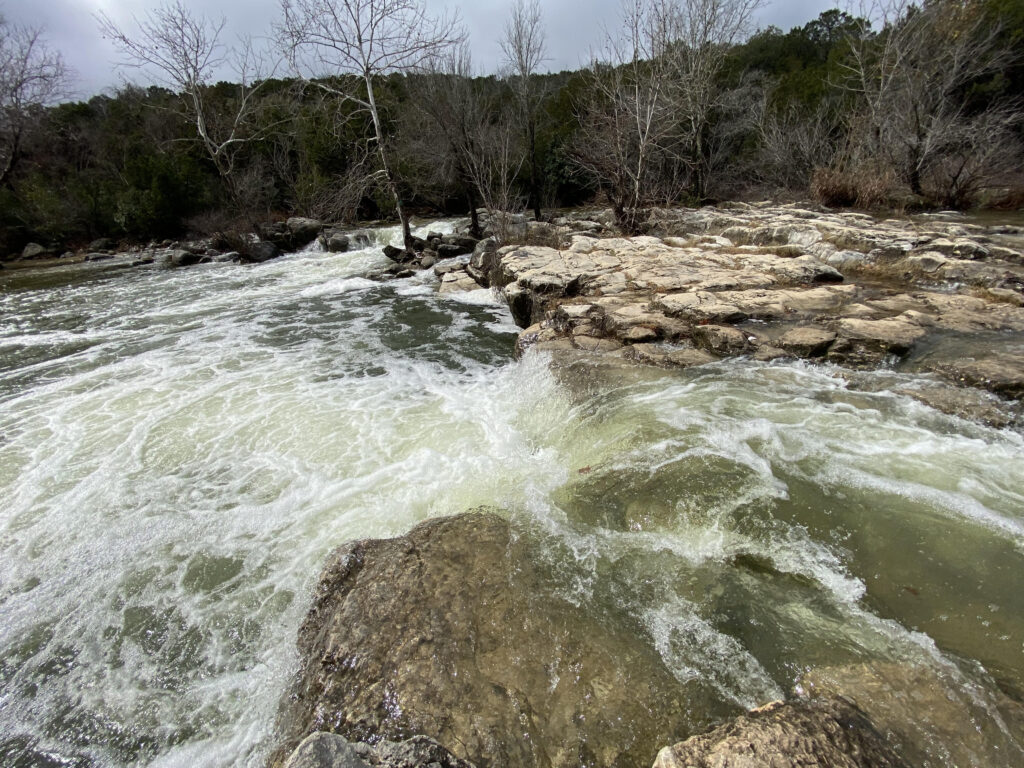
In mid-January, an arctic blast swept across most of the United States. The Texas Hill Country felt the brunt of this cold front from Sunday, January 14, through Wednesday, January 17, with temperatures lingering near or below freezing for over 72 hours. Although the period was predominately dry, some precipitation did fall and is suspected to be “factory effect snow”.
Following this, Central Texas experienced substantial rainfall. Notably, area creeks, such as Onion and Barton, saw significant flow for the first time since 2022. Most importantly, this flow occurred over the recharge zone. While the recent rain is already having a positive impact on groundwater levels and spring flow, it may take up to two weeks to observe its full effect. However, the District anticipates remaining in drought conditions due to two consecutive years of below-average rainfall and consistently high summer temperatures. In the next month District staff and Board will evaluate updating drought stage conditions.
Rainfall
The Austin area is concluding January with an average 6.6 inches of rain across the District (figure 1), currently ranking as the fifth-wettest January on record. This surpasses the monthly average by 4.4 inches. It seems that El Niño, along with the anticipation of a wet winter, has indeed made its presence felt.
Regardless of what happens in February, this meteorological winter (December-February) will be considered “wetter than normal.” Austin has recorded 8.5 inches since December 1, which is above a typical winter’s total of 7.3 inches. Historically, El Niño winters average 9.4 inches by the end of February. According to weather forecasters, El Niño conditions are expected to persist through the spring.
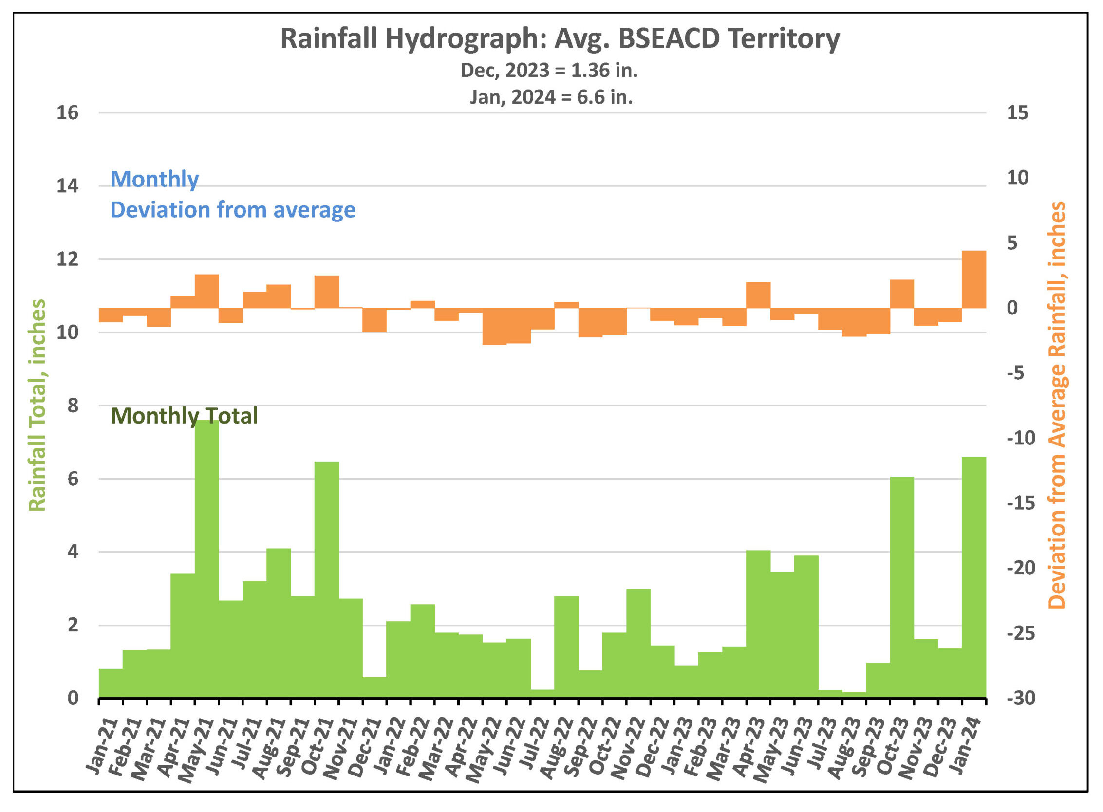
Figure 1. Monthly deviation from average and monthly total rainfall in District’s territory.
Barton Springs Flow
January’s widespread rainfall across the recharge zone had an immediate effect on spring flow. Barton Springs discharge elevated from 23 cubic feet per second (cfs) on January 22 to as high as 73 cfs on January 26 (figure 2). For reference, the average flow for the springs since 1978 is 68 cfs.
While Barton Springs discharge rate is currently above Stage II Alarm Drought, the District takes the 10-day average into consideration for drought status. It could take several weeks to see the lasting effects of the rainfall, and the District Board of Directors will take this into consideration when making decisions on moving drought stages.
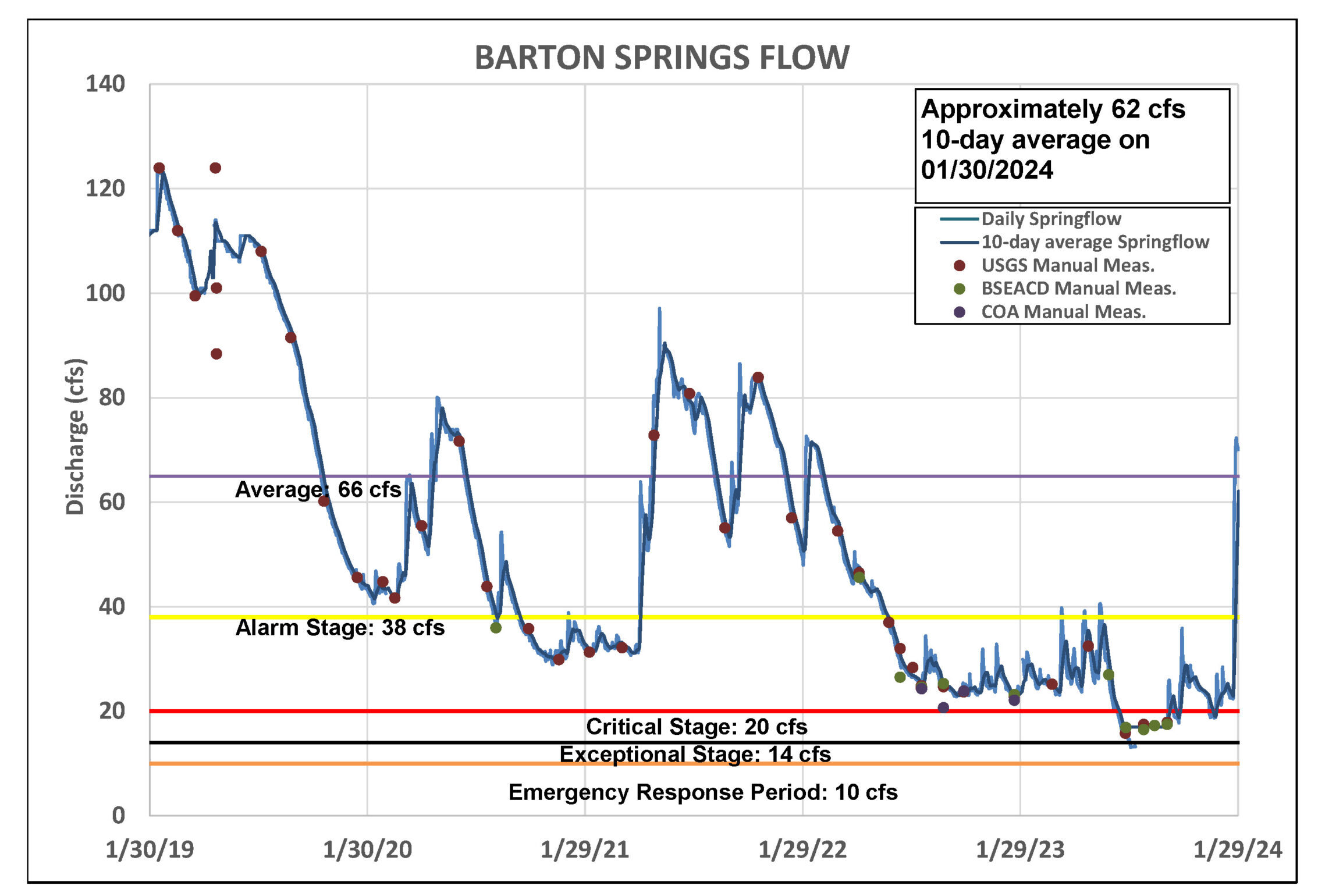
Figure 2. Barton Springs flow for the last five years.
Lovelady Monitor Well
The Lovelady monitor well has seen a positive response to the recent rains, with water levels rising by approximately 4 feet so far (figure 3). Groundwater levels were as low as 456.7 feet-mean sea level (ft-msl) on January 20, reached 460.5 ft-msl on January 30, and continue to climb. Anticipated ongoing increases in groundwater levels are linked to the continued flow of creeks, allowing water to enter recharge features such as fractures, caves, and sinkholes. It could take another week or two to see the full impact of January rains. Forecasted rainfall later this week will also have a positive impact on Lovelady levels as a result of soils being saturated and primed for additional recharge.
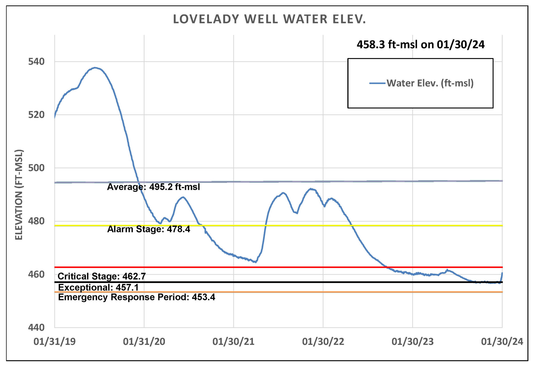
Figure 3. Lovelady groundwater level over the last five years.
Upper and Middle Trinity
Water levels in the Upper Trinity (green) have finally seen a significant rise, with an increase of nearly 20 feet. Meanwhile, the Middle Trinity (purple) continues to rise due to late 2023 rains (figure 4). It could take a couple of weeks before we observe the Middle Trinity’s full response to January rainfall.
In other news, Jacobs Well flow returned reaching as high 30 cfs. Flow quickly decreased to 5 cfs as of January 30. The Blanco River at Wimberley also experienced a surge in flow and is currently reporting 22 cfs.
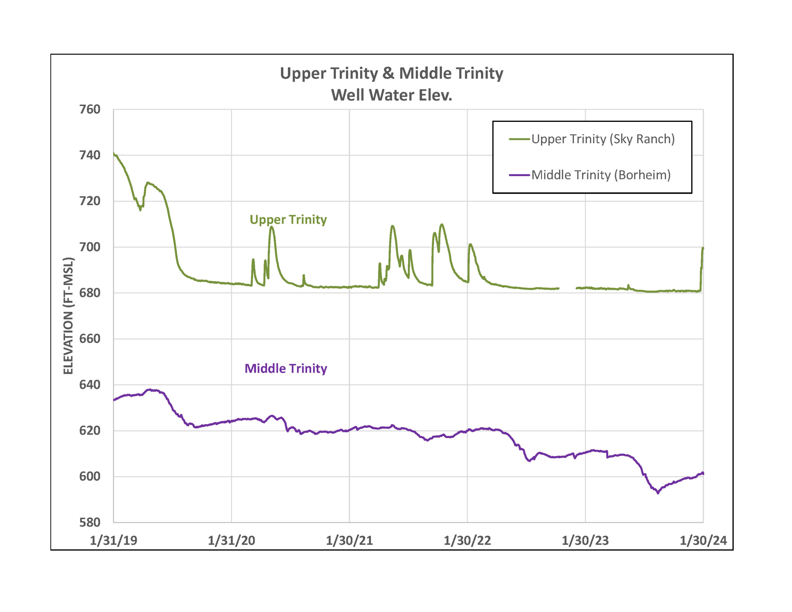
Figure 4. Water levels in an Upper Trinity well (green) and Middle Trinity well (purple) over the last five years.
Forecast and Conservation
Early forecasts show La Niña will likely be the atmospheric pattern for summer 2024. La Niña typically brings drier weather for a lot of the southern United States, meaning we’re not out of the woods yet regarding drought. It’s important for our community to actively conserve water resources and brace for a third summer of below average precipitation and above average temperatures.