May brought a mix of dramatic weather events to Central Texas. Camp Mabry recorded its first triple-digit day on May 13 marking the third earliest occurrence on record.
On May 28, a powerful microburst swept through the northern Austin area, delivering high winds, intense hail, and substantial rainfall. Some areas received up to 3 inches of rain; however, this storm missed District’s recharge zone and had no measurable impact on the aquifer segments we monitor.
While these weather events were notable, overall rainfall totals last month were less remarkable. May saw above-average precipitation, but it was not enough to significantly ease drought conditions or shift the District out of Stage III Critical Drought.
Rainfall
In May Camp Mabry recorded 6.6 inches of rain, while Austin Bergstrom International Airport (ABIA) recorded 5.5 inches for an average of 6.1 (Figure 1). This is 1.1 inches above the historical monthly average of 5 inches. The Barton Springs segment of the Edwards Aquifer did benefit from consistent rainfall spread across several days, which helped water enter recharge features and become groundwater—a critical component of aquifer health.
Still, the slightly above average monthly rainfall is not expected to raise groundwater levels substantially. The District will remain in Stage III drought for now. To move up out of this drought stage, the recharge zone would need to experience sustained, widespread, above-average rainfall over several months.
Looking ahead, June is typically the area’s third wettest month, averaging 3.7 inches of rain. We’ll watch closely to see if the coming weeks bring the sustained moisture needed for meaningful groundwater level recovery.
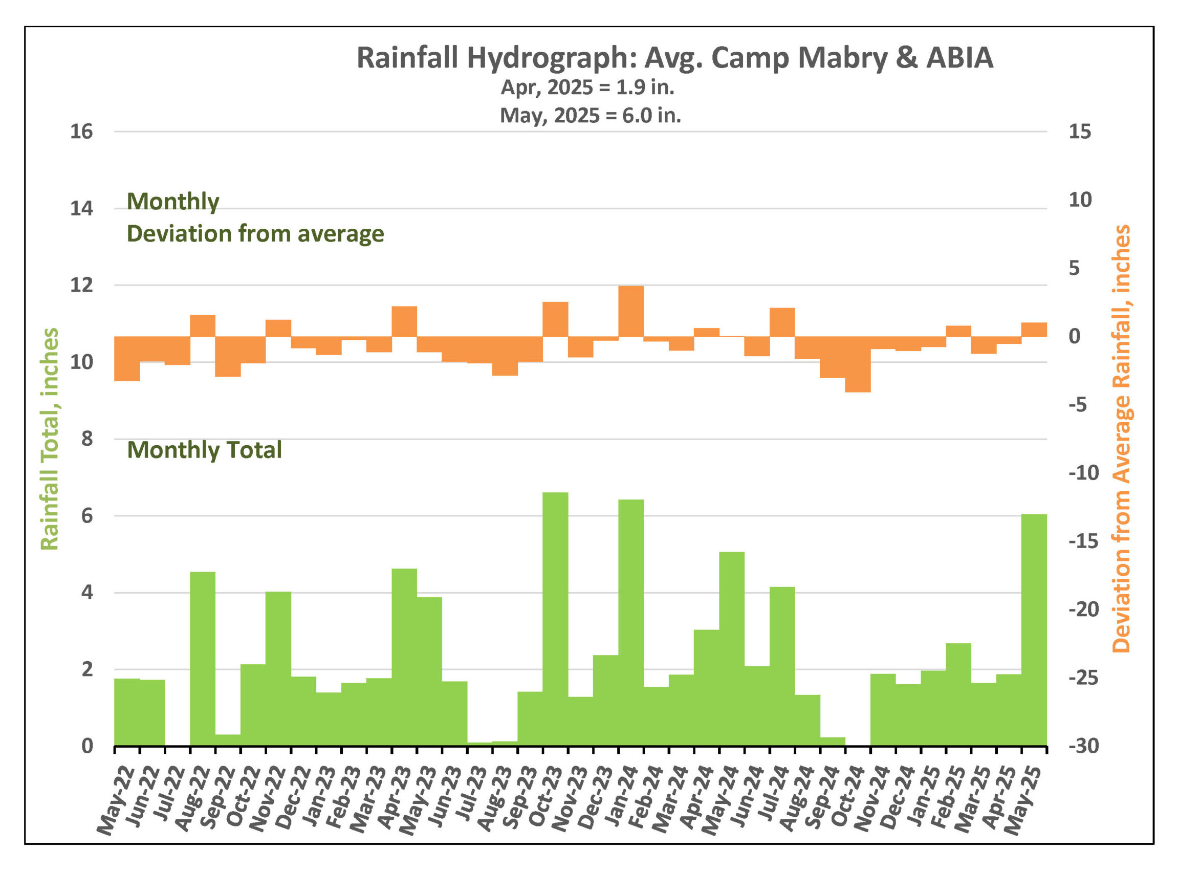
Figure 1. Monthly deviation from average and monthly total rainfall in District’s territory.
Drought Triggers and Status
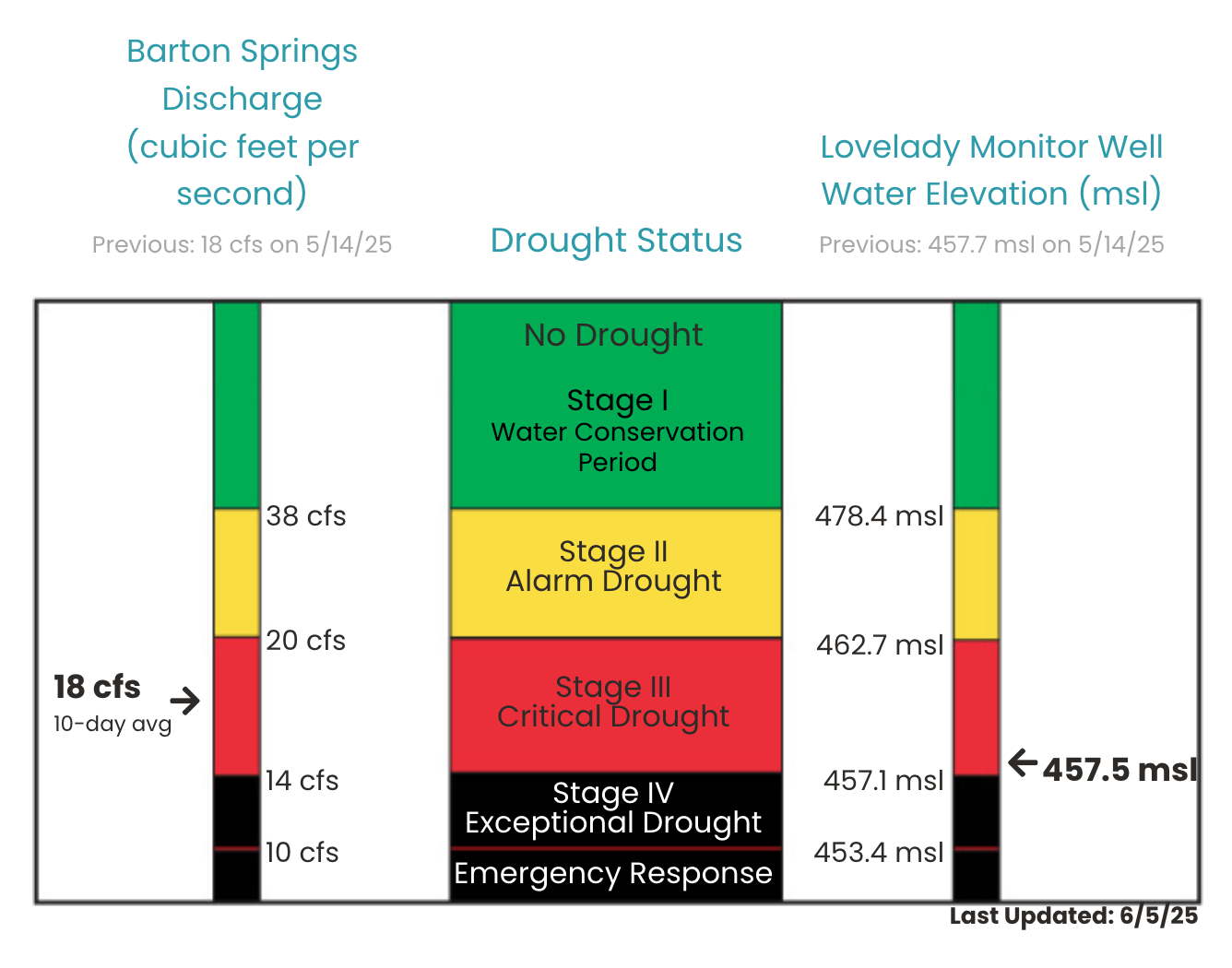
District Drought Chart as of June 5, 2025 displaying 10-day averages for springflow at Barton Springs (left) and groundwater levels at Lovelady monitor well (right)—both of which play a role in determining the District’s drought stage.
Barton Springs Flow
Similar to March and April, springflow levels at Barton Springs in May remained near the Stage IV Exceptional Drought threshold. A significant amount of last month’s 6.1 inches of rain fell over the Edwards Aquifer recharge zone where rainfall is most effective in replenishing groundwater. While not all the rain occurred in these areas, enough moisture hit the recharge zone to help stabilize springflow and prevent a further decline in aquifer levels.
In response, springflow at Barton Springs has held steady between 17 and 20 cubic feet per second (cfs), temporarily slowing the overall decline ahead of Texas’s typically dry summer season.
The 10-day average springflow at Barton Springs is 18 cfs (see Figure 2) as of June 5. This estimate combines the most recent manual measurement—taken by District and USGS staff on May 14, 2025—with data from the USGS gauge. The next manual measurement is scheduled for June 10.
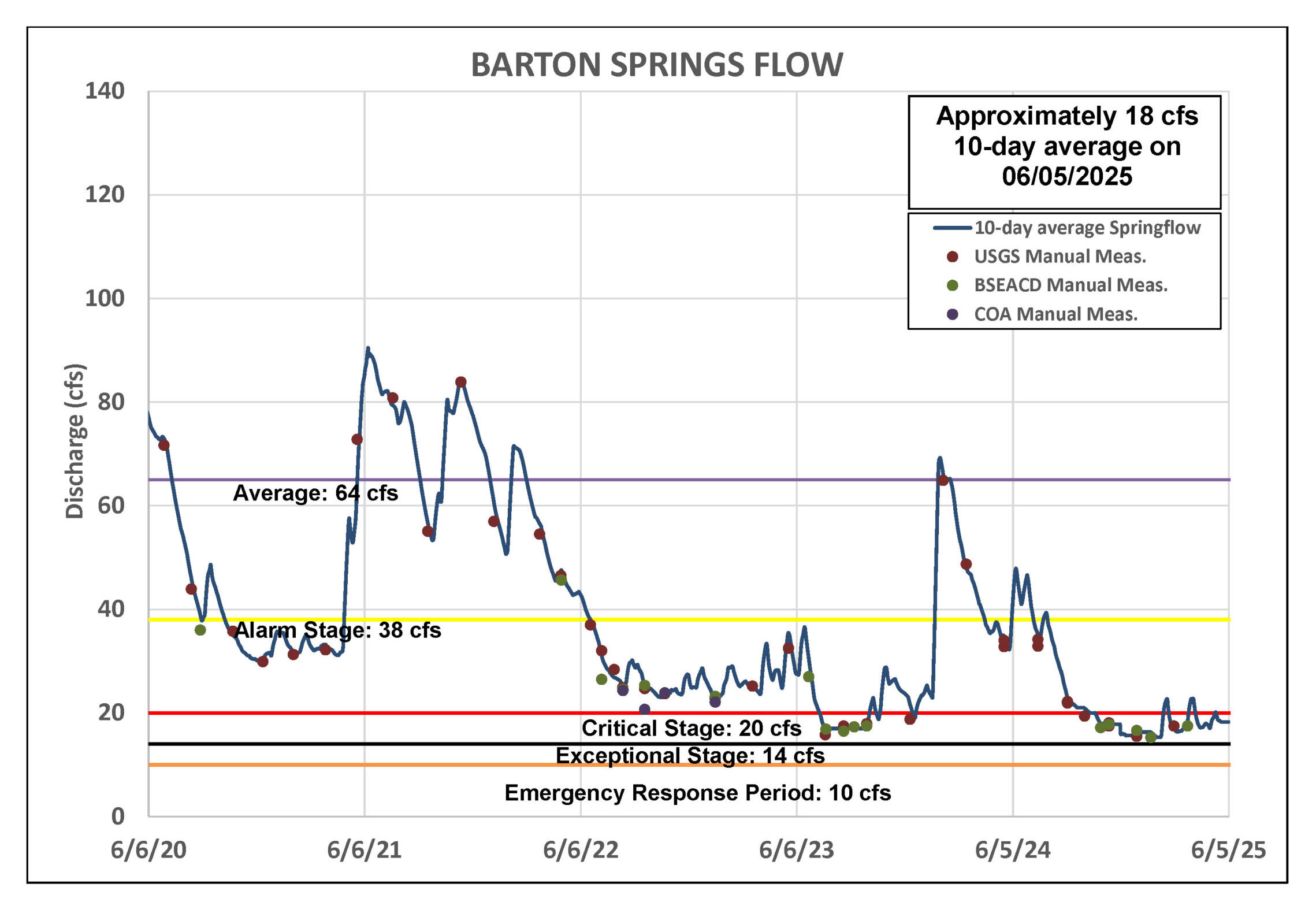
Figure 2. Barton Springs flow for the last five years.
Lovelady Monitor Well
As of June 5, the 10-day average water level at the Lovelady monitor well measured 457.5 feet above mean sea level (ft-msl), keeping it within the District’s Stage III drought threshold and just 0.4 feet above the Stage IV drought threshold (see Figure 3). For context, this represents a 0.2-foot decline since May 5. As is typical at the Lovelady well, water levels often show a delayed response to rainfall, and it may take time for any positive effect to appear. If Lovelady levels don’t experience a rebound from the May rains and/or the area receives below-average rainfall in June, water levels at Lovelady could drop below its Stage IV drought threshold sometime in July.
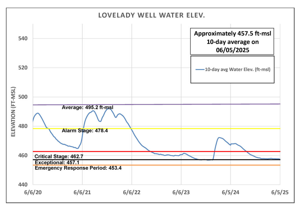
Figure 3. Lovelady groundwater level over the last five years.
Trinity Aquifer
Water level in the Lowe-Coronado Middle Trinity monitor well, located in the Rolling Oaks neighborhood of Driftwood, has declined by 9 feet since March and 3.5 feet in the last month (Figure 4). Despite above-average May rainfall within the Upper and Middle Trinity recharge and outcrop zones, located in western Hays and southern Blanco and northern Comal counties (see map), water levels in monitor wells within the Upper and Middle Trinity aquifers continue to decline. It is still possible that a delayed response to the May rains will occur in the coming weeks.
Jacob’s Well Spring (JWS) experienced a brief spike in flow in response to the rainfall late last month, peaking at 14 cfs. It has since dropped back to around 1 cfs or lower. Similarly, the Blanco River at Wimberley gauge rose to 32 cfs but has since decreased to between 6 and 8 cfs, which is still an increase from the pre-rain flows of 3 cfs.
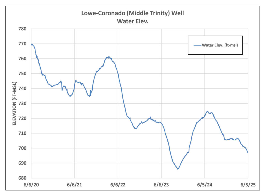
Figure 4. Lowe-Coronado (Middle Trinity) monitor well water-level elevation.
Highland Lakes
Lake Buchanan is 56% full and Lake Travis sits at 44%, bringing the combined storage of the Highland Lakes to 49% capacity. This is 2% higher than last month. The widespread rainfall in late May was welcomed and helped raise the levels of the Highland Lakes. LCRA cautioned that the rains were “definitely welcome, but were not drought breakers.” Like our groundwater resources, lakes Travis and Buchanan need steady, wide-spread rainfall across regional watersheds to drastically increase levels. For now, both the Lower Colorado River Authority (LCRA) and the City of Austin remain under Stage 2 drought response measures at this time.