It has been one week since the devastating floods impacted our neighboring communities. As stewards of water resources, this is a painful reminder that while water is precious and something we work to protect every day, it can also be a powerful and destructive force.
This event has affected many of our fellow Central Texans. At the District we recognize how deeply interconnected we all are—through shared aquifers, rivers, and creeks, as well as through the towns and landscapes we care about. These connections run deeper than jurisdictional boundaries, and in moments like this, they remind us of the importance of community and supporting one another as the region recovers and rebuilds.
June Conditions
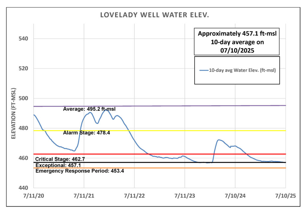
While the District did not experience any 100-degree days last month (marking the first June without a triple digit day since 2019) the region still experienced below-average rainfall. By the end of June and into early July, the 10-day average groundwater level at the District’s Lovelady monitor well had dropped to the Stage IV drought threshold.
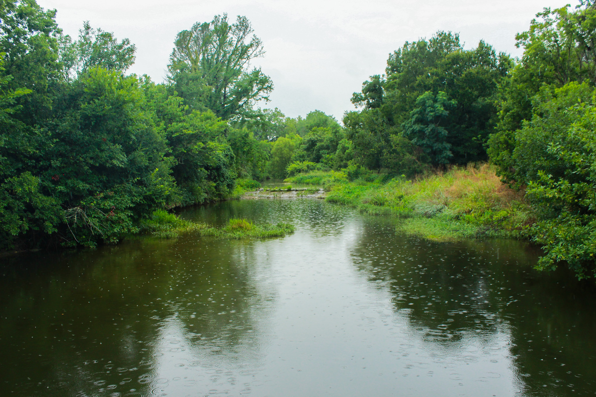
As the District prepared to declare the next drought stage, early July brought 2 to 6 inches of rain across our territory and recharge zones. Creeks that feed segments of the Edwards and Trinity aquifers in our District—such as Bear, Onion, and Barton—are now experiencing sustained flow, a positive sign for groundwater levels.
The District is actively monitoring the Lovelady well to assess how it responds to the recent rainfall. Because aquifer levels can have a delayed response to recharge events, the full impact of the storms may not be evident for several weeks. In the meantime, our team will continue to closely track groundwater conditions.
Rainfall
Camp Mabry recorded 0.85 inches of rain in June, while Austin-Bergstrom International Airport (ABIA) recorded 2.4 inches, resulting in a combined average of 1.6 inches (Figure 1). This is about 2 inches below the historical June average of 3.5 inches. This resulted in the Barton Springs segment of the Edwards Aquifer receiving little to no recharge last month. However, July—typically our second driest month of the year—has brought 2-6 inches of rain so far with much of it falling over the recharge zone.
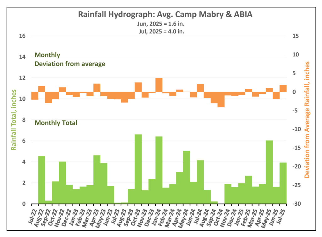
Figure 1. Monthly deviation from average and monthly total rainfall in District’s territory.
Drought Triggers and Status
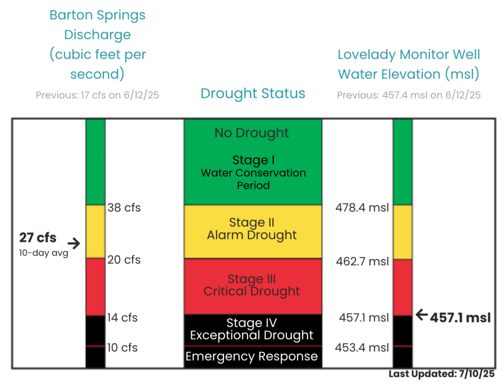
District Drought Chart as of July 10, 2025 displaying 10-day averages for springflow at Barton Springs (left) and groundwater levels at Lovelady monitor well (right)—both of which play a role in determining the District’s drought stage.
Barton Springs Flow
Minimal rainfall, limited aquifer recharge, rising temperatures, and increased water use in June resulted in springflow shifting from a slow decline to a rapid drop. In fact, City of Austin (COA) and Barton Springs Pool staff installed barriers in the dam spillways above “Barking Springs” to help maintain pool levels. On June 10, District staff obtained a manual measurement of discharge and recorded 16 cubic feet per second (cfs), which is near the Stage IV Exceptional Drought threshold of 14 cfs. Nevertheless, the early July rains have impacted springflow. A manual measurement at Barton Springs on July 9 by COA and District staff recorded a flow of 30 cfs.
The 10-day average springflow at Barton Springs is 27 cfs (Figure 2) as of yesterday. This estimate combines the two most recent manual measurements, taken by District staff on June 26 and July 9, 2025. The next manual measurement is scheduled for late July.
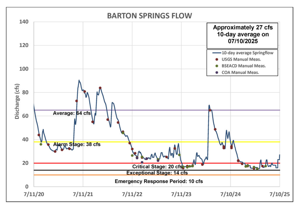
Figure 2. Barton Springs flow for the last five years.
Lovelady Monitor Well
As of July 10, the 10-day average water level at the Lovelady monitor well measured 457.1 feet above mean sea level (ft-msl), which is right at the District’s Stage IV drought threshold (Figure 3). Under the District Drought Trigger Methodology (DTM), the Board would typically be prepared to declare a deeper stage of drought based on current Lovelady levels.
That said, July rainfall in the Austin area—particularly over the recharge zone—is expected to positively impact aquifer levels. Unlike the immediate response seen at Barton Springs, groundwater level changes at the Lovelady well tend be more delayed, sometimes taking two weeks or more. As a result, the District will closely monitor groundwater levels before making any declarations. This measured approach helps us avoid frequent shifts between drought stages.
Figure 3. Lovelady groundwater level over the last five years.
Trinity Aquifer
The water level in the Lowe-Coronado Middle Trinity monitor well, located in the Rolling Oaks neighborhood of Driftwood, has declined by 15 feet since March and by 6 feet in the past month (Figure 4). While it is still too early to tell, the recent heavy rains over the Upper and Middle Trinity recharge and outcrop zones—located in western Hays County, southern Blanco County, and northern Comal County (see map)—could result in a delayed positive response in water levels in the Upper and Middle Trinity aquifers in the coming weeks.
Jacob’s Well Spring (JWS) also saw an increase in flow, peaking at around 12 cfs and currently holding steady at about 6 cfs. Similarly, the Blanco River at Wimberley rose to over 400 cfs and is now flowing at about 60 cfs, up from 12 cfs before the Independence Day rains.
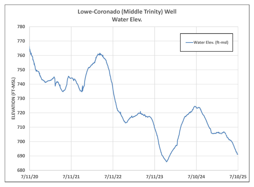
Figure 4. Lowe-Coronado (Middle Trinity) monitor well water-level elevation.
Highland Lakes
The Highland Lakes have seen a notable rise in water levels following rainfall across the Lower Colorado River Basin this month. Lake Buchanan is currently 85% full, an increase of 29% from last month. Lake Travis has also gained water, now sitting at 70% capacity—a 26% rise since June. Collectively, the lakes are now 77% full.
A lot of recent rainfall in the Hill Country occurred over the Lower Colorado River Basin, leading to a strong response in surface water levels. In contrast, less rain fell over the District’s recharge zones. As a result, groundwater levels—known for responding more slowly and less dramatically than surface water—show a more muted and delayed response in comparison.
Despite the encouraging boost in lake levels, it’s essential to maintain a conservation mindset. Continued water stewardship remains vital as Central Texas enters the hottest part of the year.