Rainfall
Camp Mabry recorded 6.1 inches of rain in July, while Austin-Bergstrom International Airport (ABIA) measured 3.1 inches, resulting in a combined average of 4.6 inches for the month. That’s 2.6 inches above the historical July average of 2.0 inches. Although July is typically the second-driest month of the year, it ranks as the second-wettest month of 2025 so far, trailing only May. Despite the recent rainfall, the District remains in a cumulative three-year rainfall deficit of about 22 inches.
This spring, a total of 9.5 inches of rain in March, April, and May kept Barton Springs flows and Lovelady well levels just above Stage IV Exceptional Drought thresholds. However, below-average rainfall in June, coupled with the typically dry summer, accelerated declines. By early July, Lovelady levels were approaching Stage IV levels once again until Independence Day storms temporarily reversed the trend.
Looking ahead, August is often dry but ranks as the fifth-wettest month historically, with an average of 2.9 inches of rainfall. Current forecasts call for near-normal precipitation this August, which could help slow or prevent further intensification of drought conditions.
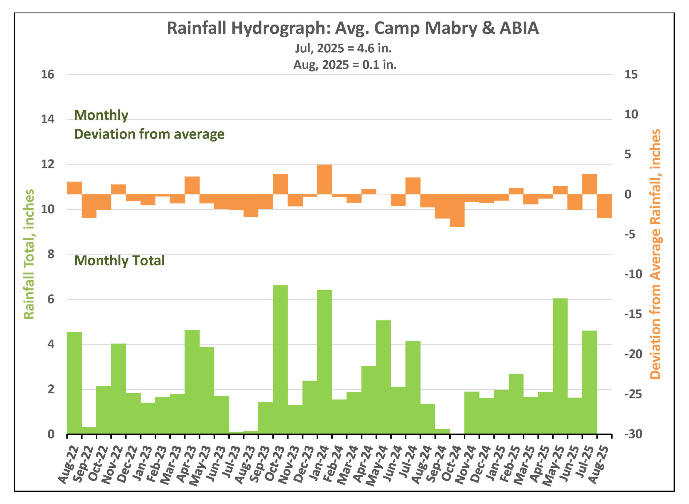
Figure 1. Monthly deviation from average and monthly total rainfall in District’s territory.
Drought Triggers and Status
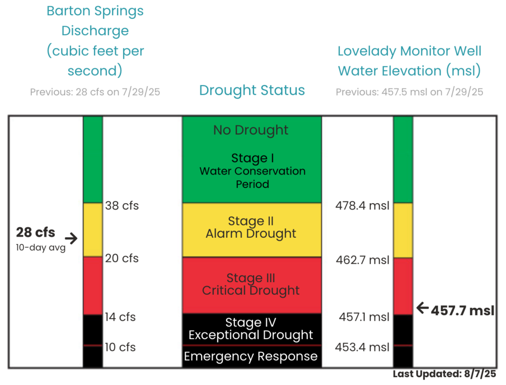
District Drought Chart as of August 7, 2025 displaying 10-day averages for springflow at Barton Springs (left) and groundwater levels at Lovelady monitor well (right)—both of which play a role in determining the District’s drought stage.
Barton Springs Flow
Early July rains had a notable impact on Barton Springs, with much of the precipitation falling directly over the recharge zone, an ideal area for aquifer replenishment. Following the storms, spring flow surged from 19 cubic feet per second (cfs) to nearly 50 cfs. Stream gauges on Barton Creek, Bear Creek, and the western portion of Onion Creek — key recharge watersheds — recorded substantial increases in flow.
Although this boost was short-lived, it provided a timely reprieve as Barton Springs approached its Stage IV drought threshold. The rain offered welcome relief, but sustained recharge from additional rainfall is still needed. Without it, springflow has once again begun to decline.
As of August 7, the 10-day average discharge at Barton Springs is 28 cfs, based on the most recent manual measurement taken July 24. The next manual measurement is scheduled for August 13.
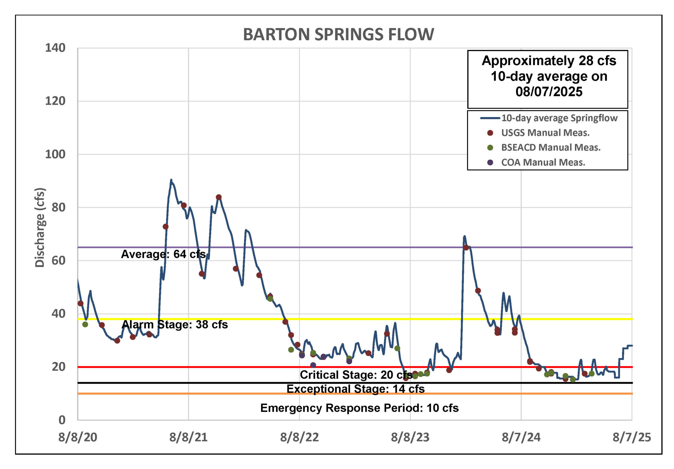
Figure 2. Barton Springs flow for the last five years.
Lovelady Monitor Well
At the start of July, water levels at the Lovelady monitor well had fallen into the Stage IV drought threshold. Early July rains briefly reversed the decline, raising levels by 0.6 feet, but the incline was temporary.
As of August 7, the 10-day average water level at the Lovelady well measured 457.7 feet above mean sea level (ft-msl), placing it in Stage III Critical Drought. The Independence Day rains had their greatest effect by July 28, after which water levels resumed their downward trend.
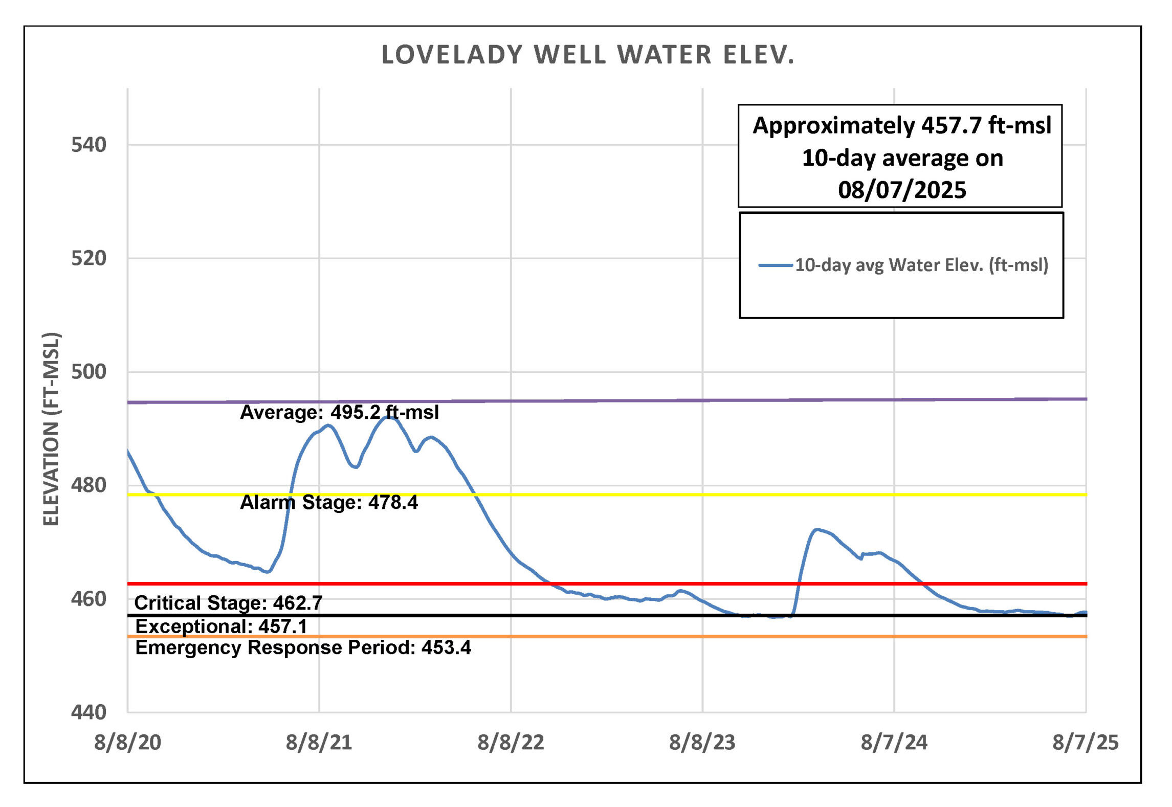
Figure 3. Lovelady groundwater level over the last five years.
Trinity Aquifer
Since March, water levels in the Lowe-Coronado Middle Trinity monitor well, located in the Rolling Oaks neighborhood of Driftwood, have steadily declined. While recent rains fell over the recharge and outcrop zones of the Upper and Middle Trinity aquifers in western Hays County, southern Blanco County, and northern Comal County (see map), aquifer levels have shown little to no response. This could reflect a delayed recharge effect, but more likely, the area is so dry that much of the rainfall was absorbed by soil and vegetation before it could percolate underground. In other words, there wasn’t enough surface runoff — rainwater flowing across the land into recharge features such as caves and crevices — to significantly raise water levels.
Jacob’s Well Spring (JWS) experienced a brief increase in flow, peaking around 12 cubic feet per second (cfs), but this was short-lived, and flows have since dropped to just above zero. Likewise, the Blanco River at Wimberley rose to over 400 cfs before declining to about 14 cfs.
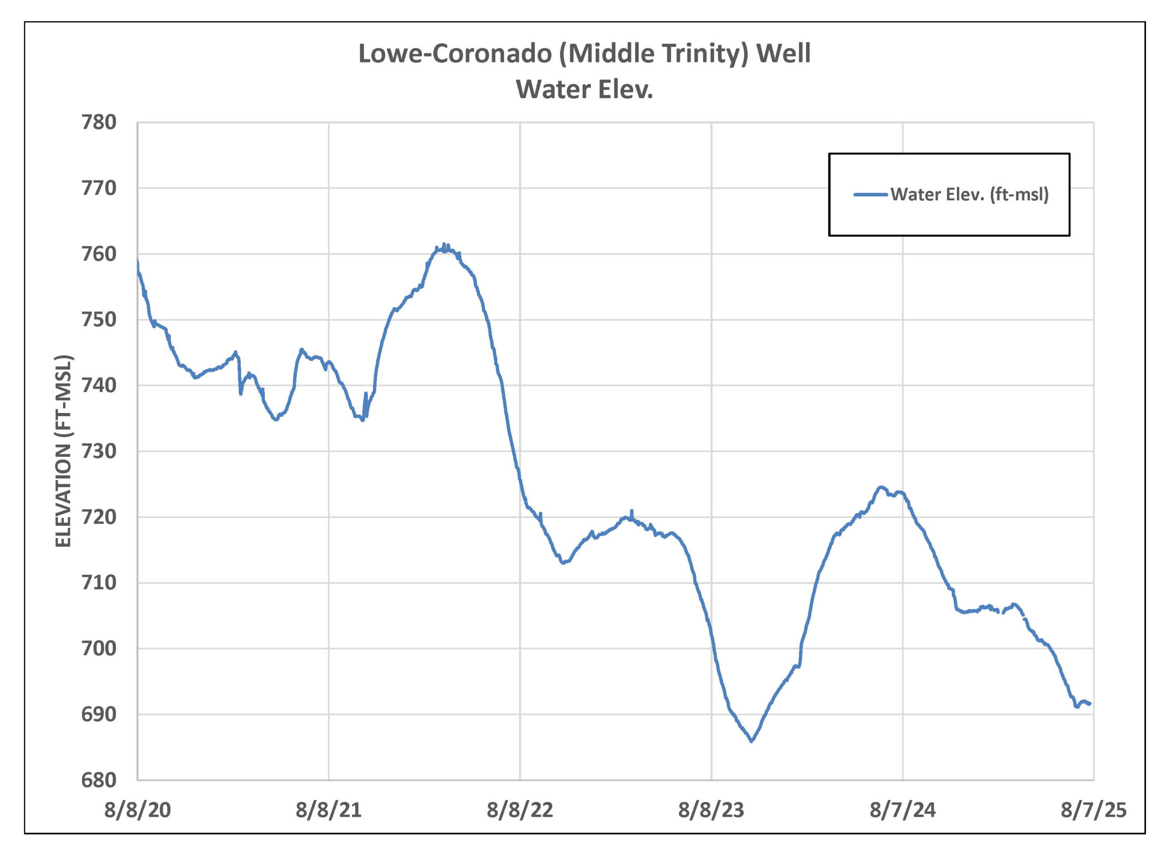
Figure 4. Lowe-Coronado (Middle Trinity) monitor well water-level elevation.
Highland Lakes
The Highland Lakes rose sharply following early July rainfall across Central Texas. Lake Buchanan is now at 99% capacity—up 14% from last month—while Lake Travis has climbed to 90%, a 13% increase since June. Combined, the lakes are currently 94% full.
Both lakes have already begun to decline due to evaporation from high summer temperatures and increased seasonal water use. This trend is expected to continue through August without additional rainfall.